So seriously, if you place the pin anywhere along the trail, does that mean that one single pin is now the way spot for the entire trail if it’s say 20 km long? Or does that mean that pins could be placed randomly anywhere along the entire trail so that you had pins every 20 m?How do you distinguish where exactly the pin should be placed, how many of them there should be, or if the one placed 20 km away is the only one you can have because it’s the one that marks the trail? I am really at a loss for how that would work if there’s no real world point of interest, rather than 20 km trail of interest.
This hasn’t worked for years. It is much harder to take them now and I don’t recommend them. A professional photographer drops them randomly here.
1 Like
The Streetview app has not worked for years. It is much more complicated to do this now and I do not recommend it. A good supporting photo with elements that can be verified is plenty. Your problem in this case is that there is no distinct visual anchor to prove the location of.
Something you can do for future submissions along this trail is to provide external evidence with links in the supporting text that proves what you are saying.
1 Like
I was waiting for someone to criticise that lol so well done.
I’ve got “Scaniverse” & “AR VOYAGE” on my wish list to check out next but these might be a bit more complex for Wayfarer use.
Must be a permanent physical, tangible, and identifiable place or object, or object that placemarks an area


I think this is the challenge. The photo above is asphalt and grass and trees. It could be anywhere. There is nothing distinct about it at all. A soccer pitch has boundaries and goals, which are distinct. Anyway, I think there needs to be a point that is independently distinguishable. Just my opinion.
1 Like
let us know if the others work easily. here is one of that photographer’s randomly dropped photospheres to show what i was working against when the default view was street view - and why i don’t like or trust photospheres

i could not figure out why so many of my nominations were being rejected for location until i installed a tool from wayfarer.tools that showed me nomination streetview. then i went on a mission to get his misplaced photospheres removed, but the quality of the photography is so good, they rarely would do it. i may be THE reason google closed down the streetview app
3 Likes
The two I mentioned are niantic early access products by the way on the Google play store,but I don’t know if the same is available on the Apple Play store.
Tools are Tools but I’ll look at anything for a short while but if they do what I need then I will continue.
1 Like
The place has to be distinct without the use of the game. Otherwise, we could nominate any leaf on the ground we want and just say, " Look for the pokestop." WF is a different mindset from the games, but still also tied to the games. It’s an odd concept.
1 Like
The trail needs something to anchor it to, in order to makr a good wayspot. Without an anchor, there is no way to distinguish this patch of trail from others. No way to really say how many and which locations along the trail are eligible.
I agree, there needs to be a focal point, such as a sign or a bench or something along those lines. Whilst I think this seems like a really great area for people to safely play Pokemon Go, there really needs to be a central, focal point for the pokestop to attach itself. Don’t be disheartened, find something along this path you can do that with.
AIが判断しているんすか?! どおりで説明を変えようが、何度投稿しようが審査に通らないわけです、歴史や地域にとって意味や意義のあるものでも史跡以外の年季の入った候補は不承認、見た目てザックリ除外されているわけですよね。 反対に、他では目にする事のない、見る価値のあるという主旨である「ユニークな」に全く該当しない、つまり基準外の筈の量販店やチェーン店等が審査を通るのは、そういった仕組みであるからなんですね。もうガッカリ、投稿する気が完全に無くなります。
A few things…
You can argue about the interpretation of the guidelines all you like, but when it comes to voting you are much more likely to be accepted with some sort of anchor (trail marker, sign for example).
You can still make photospheres, but it’s difficult and requires expensive kit. I find that photospheres are generally accurate, but user-submitted Photo Paths are woefully inaccurate. I still can’t figure out why Google was so keen to kill user content.
It helps a lot if you can provide supporting evidence for a walking trail, such as a council, parks or government website or some other reliable source. A lot of trails are marked on OpenStreetMap and it’s easy to provide a direct link to the evidence, where Google Maps is very patchy on naming trails. Also, don’t forget Bing Maps which sometimes has much better imagery than Google, you can add a link to the relevant map in the supporting text.
1 Like
" if it has meaning and significance for the history and the region, candidates that are not historical sites and have a long history will not be approved"
If candidates like these are being rejected, you have 2 appeals, each on a 20 day timer. You can have humans look at the decision. The ai is machine learning, so it learns from its mistakes. I get your frustration, but this ML model has helped weed out terrible submissions causing a backlog in reviews, and can even approve something it can understand.
詳しくありがとうございます。
申し立ては、1つの候補に1回表示されることは確認していますが、2回出来るんですか。
農業共同組合の建物が毎回「一般的企業」という理由で否認さる為、文面に「農家の集まりの組合であって、企業ではない」と書き加えて申請しても、審査だけでなく、申し立ての結果も「一般的企業」という理由で否認。建物も古いので、写真からの先入観での否認もあり、結局は説明も読んでいない審査員が非常に多いと思います。
こういった誤解のある結果もAIは学習してしまうのではないかという懸念が生じます。
とうして審査員の質が下がったのか?アイテムほしさにウェイファーラーチャレンジをしたり、最近の承認される候補の偏り、良い評価と悪い評価のとちが多いかで決めるような審査、これでは正当な評価が期待出来ないように思います。 一旦、以前の評価システムに戻してみてはどうかと考えます。最低限、偏りは無くなるのはないかと思うんですが。
You cannot appeal the same rejection twice, but you can appeal a separate rejection of another submission of the same thing. I have an award winning, decades old, town favorite restaurant that took five submissions and two appeals to get accepted.
I think that saying it is a “farmer’s association, not a business” is missing the point that they don’t see how it meets criteria as a place of exercise, exploration, or being social. You need to explain how a farmer’s association meets at least one of those criteria.
I also think that some reviewers have made up their minds before they get to the supporting information, and I have begun putting most of the interesting information about the Wayspot in the description. It also make the game location more interesting to be able to read about it that way if accepted and included.
I don’t think the quality of reviewers has gone down necessarily, but I do think there is a lot of confusion about what should be accepted.
2 Likes
I agree that expensive gear is needed to get walking paths without signs in game. And that doesn’t seem fair. Both of these were rejected before I broke out the drone.

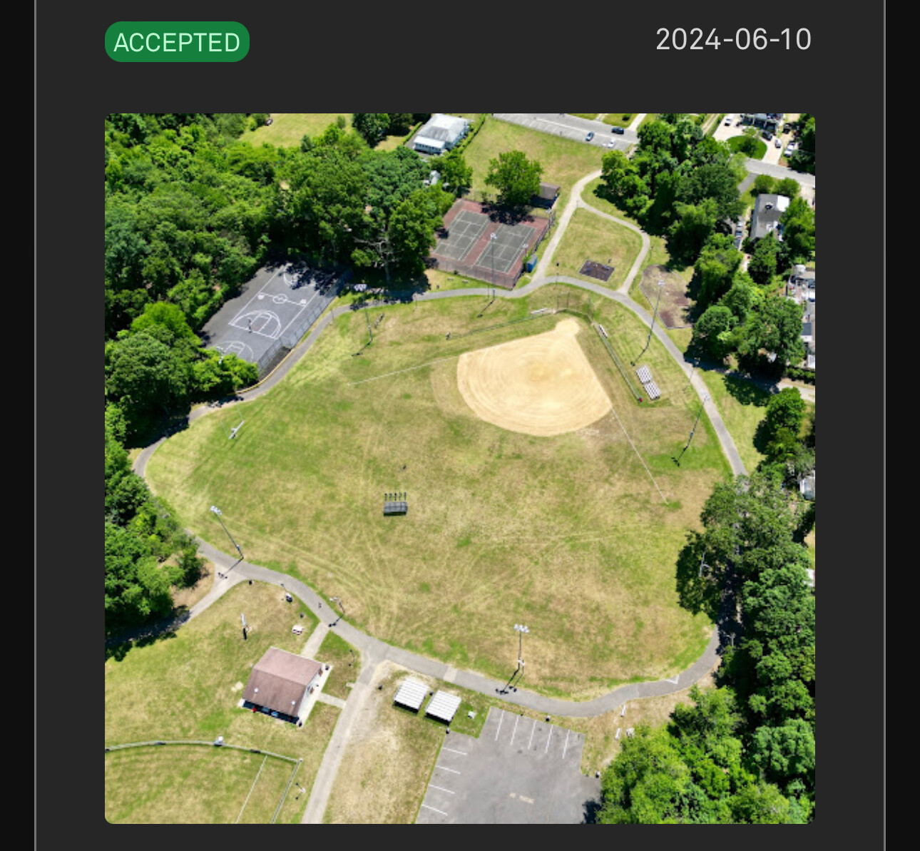
As a matter of fact one of these was rejected for fake photo even though I placed the drone in the supporting photo. But I got it in on appeal.

詳しいですね。分かりやすいご説明、ありがとうございます。
参考にさせていただきますね。
1 Like
I would suggest that you travel the trail and either direction till you come to a sign or other marker that is permanent it doesn’t have to refer to the trail itself. You could just call it “(”“”) marker along trail "- then finish the description with what you just said
Not an anchor per se, yet a sign or trail marker or identifying item, even a dog poo baggie station or bench, nature sign, an arrow pointing somewhere, etc. would work as well, at the very least, identify the trail as a public trail or walking path & not a random rural driveway or road or holler’ as they would say in Appalachia. The pictures look like every holler’ I’ve ever been down when I lived up North and it looks exactly like my mother’s driveway to her farm in Ohio currently…and most def, don’t mention Pokémon. I have know a ton of Ingress players who down vote anything mentioning Pokémon Go. I play both games yet always submit nominations thru Ingress myself…I’ve been playing for over 10 years and have meticulously selected very specific verbage in order to get my nominations approved…