I’ve submitted a couple of Wayspots recently and got the following knock-back for them both:
“This submission was declined by Niantic’s automated process for not adhering to Wayfarer criteria”
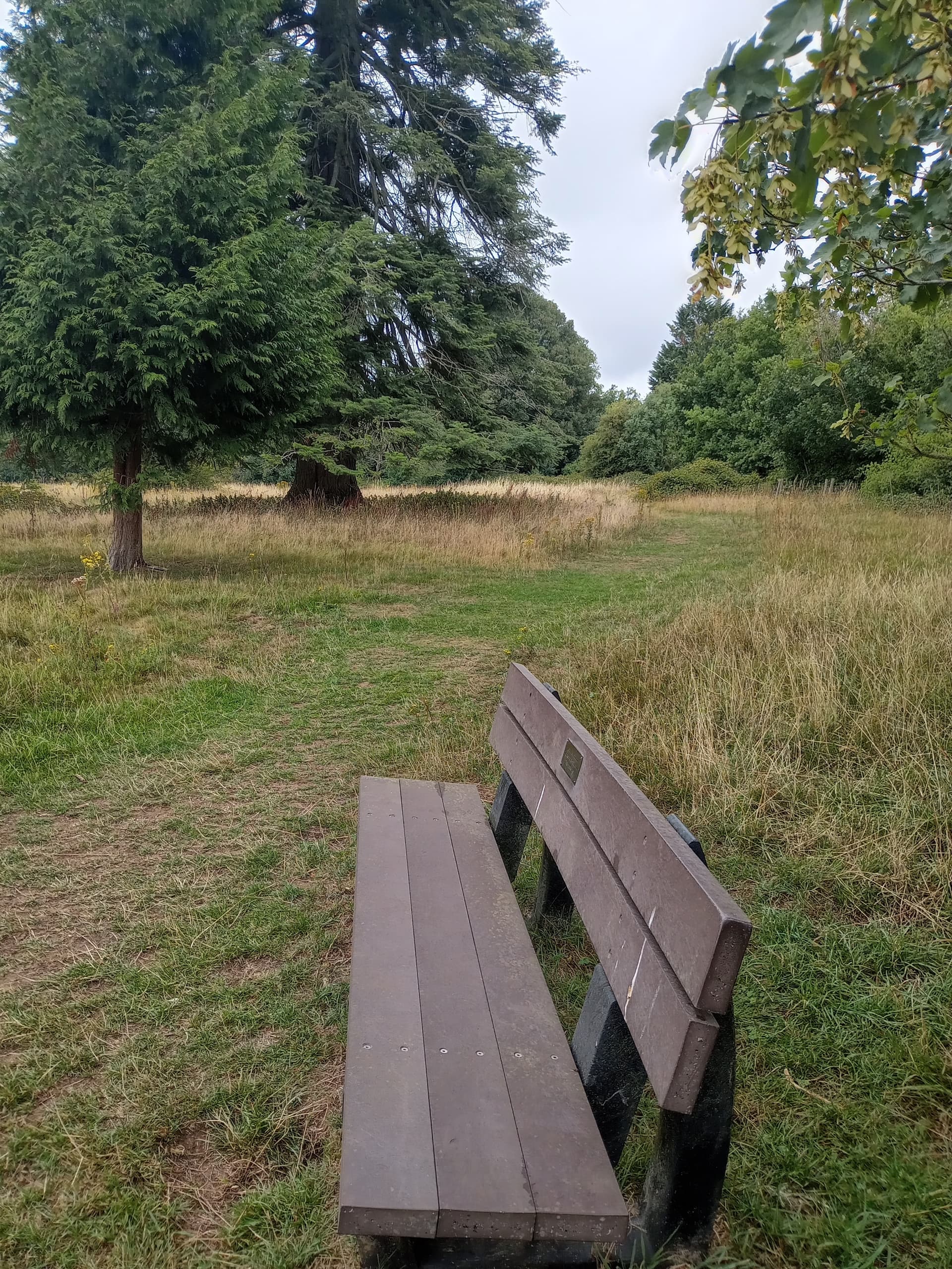
This was one of the submissions (the other is similar, but of a different bench)
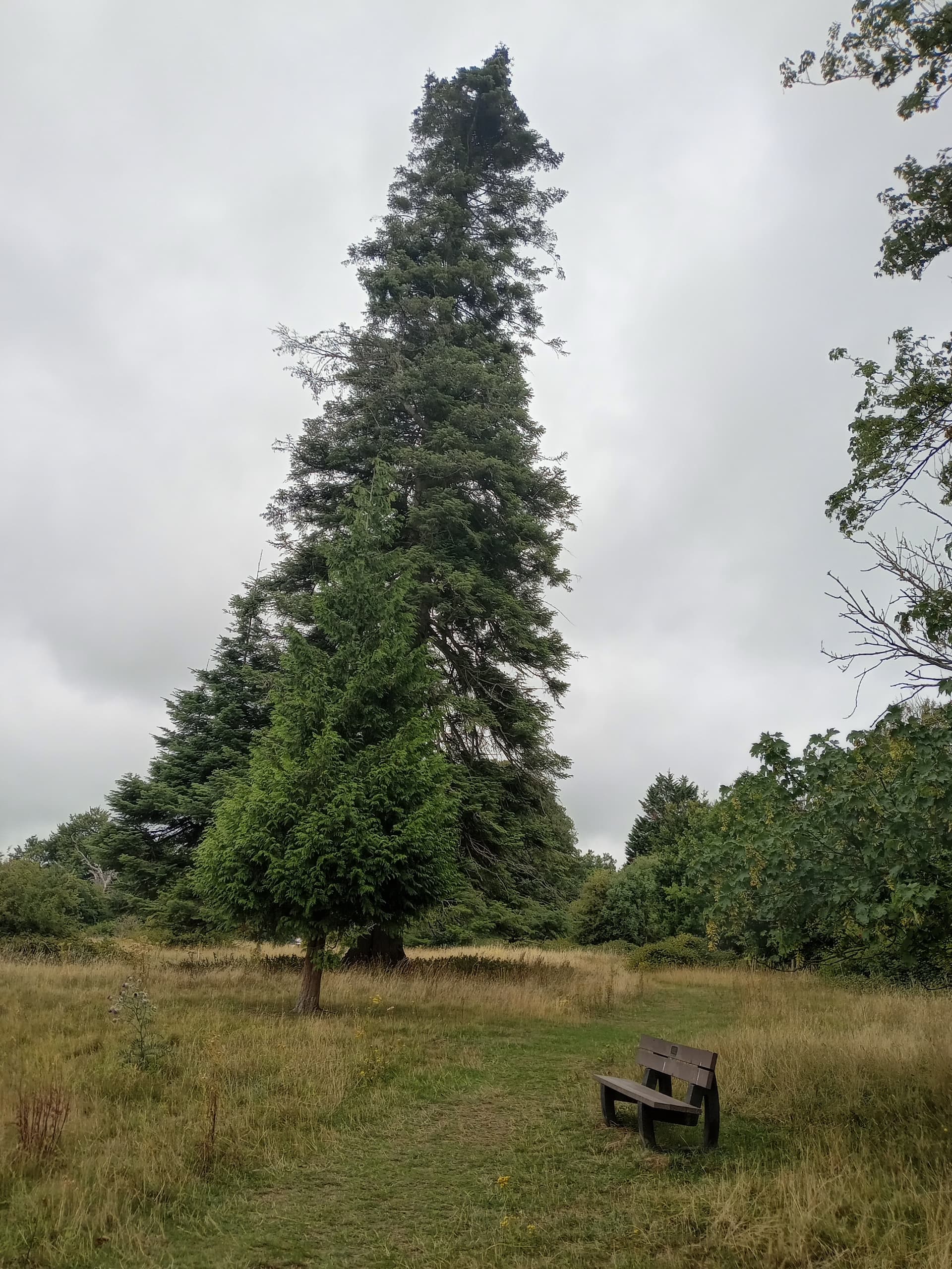
Danesbury Park is a local nature reserve with many paths crisscrossing the grassy areas between mature trees. If you need a break from your walk, or just want to relax and enjoy the view, there are lots of benches, like this one near the tallest tree in the nature reserve.
Supplementary info:
Danesbury Park nature reserve is very popular with locals, who use it to walk their dogs, get some exercise or simply appreciate nature such as the red kites who are frequent visitors. The bench is easily accessible from multiple paths across the park.
As it’s a nature reserve and I specifically mention exercise, I don’t understand what I’m doing wrong. The photos are good quality (I think), clearly showing the bench I mention and the nature all around it.
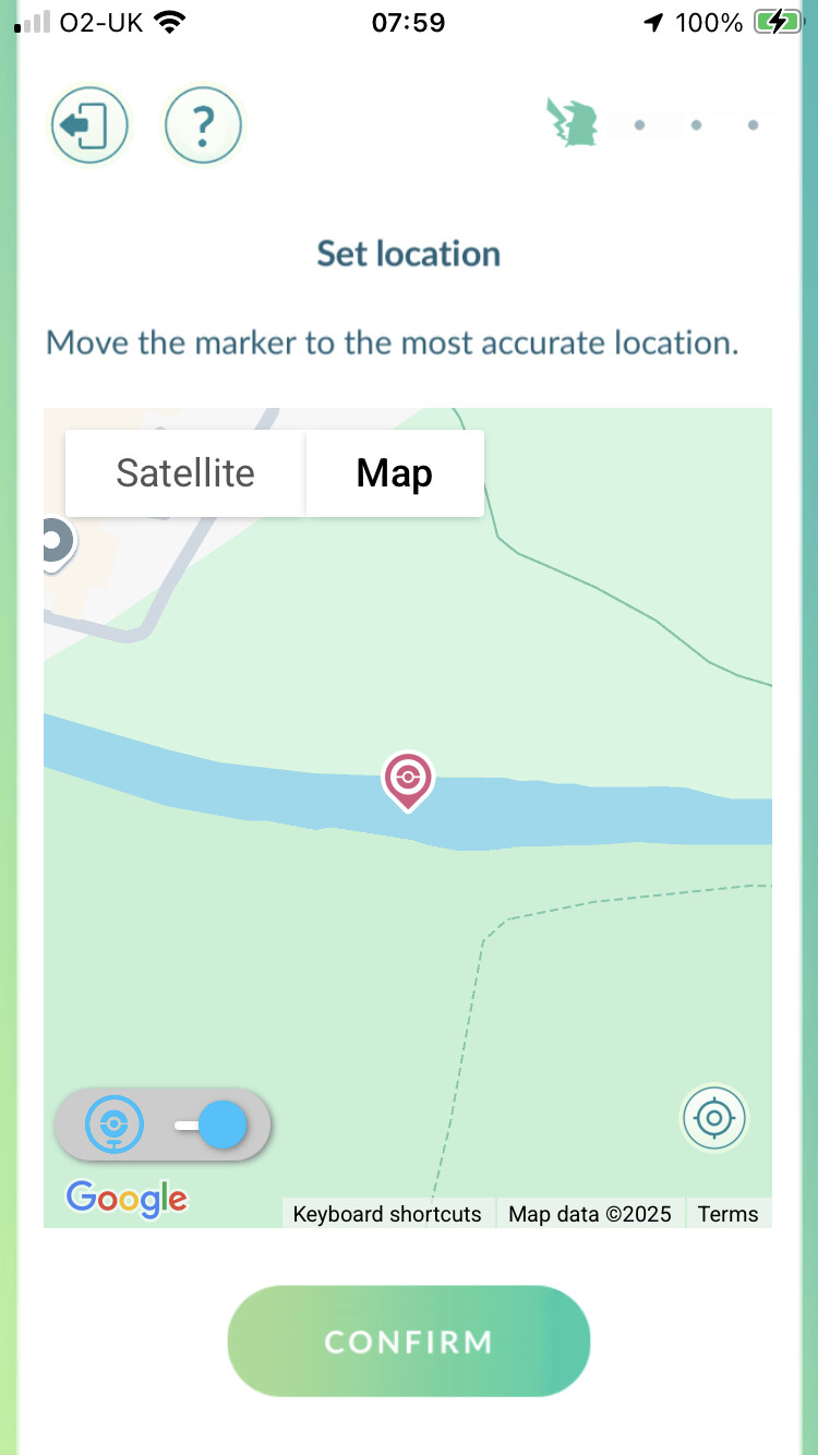
When I selected the location, I zoomed right in and you can see the bench. However, in the map they show you can’t even see the paths far less the bench. How would I get past that?
Any help or guidance would be very much appreciated. Thank you.
Glad you found the forum and I’m sorry you are having trouble with your nominations. Note I did move this conversation from Review Support to Nomination Support.
The nature preserve is an excellent nomination. I think you are running into trouble with the photos. The machine learning (ML) filter does not seem to like too much greenery or nature in a photo without a good anchor. Is there a sign for the nature preserve? You may be able to use the bench with better framing (I leave this advice to others). But my concern is if this is one of many benches and paths there how is this spot identifiable? I like to choose spots that are easy to identify even if I don’t have the game map leading me there.
Thanks for moving it to the appropriate thread. This is the first time I’ve posted, so I’m just learning!
I thought the ‘tallest tree’ in the park was fairly identifiable and the photos showed that. Most of the benches I was considering using also have a dedication plaque so maybe I should use that instead. I could rename it accordingly (e.g. ‘Enjoy Yourselves Bench’ from the quotation or ‘Robert’s Bench’ as that is who the dedication is for, but use the second image to show the setting. Would that be better?
Benches can be tricky. Here is some information about Memorial and other types of benches from the Clarification Collection.
Hmmm. I missed the tallest tree aspect. How do you know it’s the tallest tree? Is it really easy to identify? I think even with a good right up I’d struggle to accept ‘tallest tree’ as it’s very hard to verify.
I’m sorry I need to jump off for a bit and get some work done. Hopefully others can tag in and continue to help.
Memorial Benches are usually Rejected unless they are of someone notable or they are used as an “anchor point” to something else such as a scenic viewpoint.
I regards to “Tallest Tree” is this something official. Is there a plaque?
Sadly, there isn’t a plaque but it’s very obvious that it’s the tallest and can be seen from quite some distance away. All the plaques on the benches I had in mind are of ‘ordinary’ people - I just wondered about using that element if they didn’t like the scenery label. One plaque isn’t a memorial, just that it’s been provided by a local residents’ association so maybe that would work. All the benches I picked had scenic viewpoints - the idea of using the memorial plaque was just to try to differentiate them. Thanks for your advice
The problem with the tree is that every park has a “tallest tree in the park”. This would need to be something more like “tallest tree in the country” and you would need evidence to prove it.
In regards to benches I admit to be, and I believe a lot of others are the same we start at the point of “Reject” and only then look for something that elevates this as something special. I have been involved in “discussions” on what counts as a “Viewpoint”. My view is that every bench has a view so it needs to be something more to pass.
This type of park can be frustrating, it should be eligible but really it needs an anchor. Sometimes that’s an obvious think like a sign or a gate. If there isn’t one then it gets hard - not just because of Emily, but also because many reviewers will see a patch of green and just assume it’s some grass.
Benches can work if they have a good view, and you can sell them as viewpoints. Many parks have walking trails and trail markers are usually an excellent choice - try to give each one a unique name if you can, if they are named trails there are usually easily accepted, coloured ones are common too. Plain old arrows are harder to get in.
Old maps can sometimes reveal things that aren’t obvious on modern ones. For example, the old OS maps available at https://maps.nls.uk/ reveal that there was a cricket pitch and pavilion close to your proposed wayspot, before that it was a tennis lawn. Maybe there are some hidden artifacts in the park your could research and turn into interesting wayspots.
I must have driven past this place hundreds of times and never known it was there
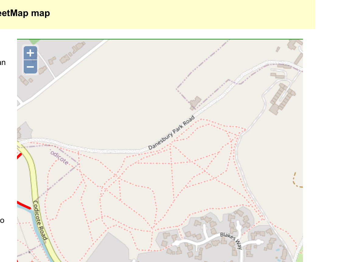
Thanks for your input. I’ll enjoy having a look at those maps. The problem with Danesbury Park is that there are multiple paths and multiple gates/entry points. But nothing is labelled! Lots to explore, but no specific paths are identified. I managed to get one gateway allowed, but other similar ones all crashed and burned. It’s frustrating as it should be such a good place for wayspots, but nothing seems ‘official’ enough. Thanks again for your help.
That was a cracking idea! I’ve just had a close look at the old maps and compared them to what is there now and the tennis lawn is right by one of the benches I had planned to include! Thank you.
I created a joint image linking the historical map and the current view and have permission already granted by NLS to do so. I’ll go ahead and use that to submit. Thanks again for the tip.
If the bench is not visible from street view or satelite, u can use gps tagged photo (foto will have gps written)
That can help confirm its location.
Like other said. Bench is hard sell but its not impossible. It depends on location and how submitter present it. Bench withview point is definitely eligible. But i am not sure how your local community see it.
Thanks. The bench is visible in satellite view, just not on the map that appears in the submission itself (i.e. the map created by the app, not the zoomed in image where I placed the pin). I’ll have another look at selling the bench better. Thanks for your advice.
Well good luck. People here can only give advice on how to improve your nomination. But the one need to be convinced is reviewer from your local area . Most people here probabaly wont even see your nomination.
Lots of paths as you say that criss cross the park but none are solid red which is what is used to indicate a public right of way.
Longer term suggestion…..try talking local councillor or the parish council to see if they could consider promoting healthy lifestyles by creating circular walks to encourage walking 1 mile or 2? A map with routes would be good and some simple signage at those other entrances. Yes it would take resource but it could be a community project. You can only try to plant these thought seeds in the minds of councillors - when an election is due they might be receptive
Many thanks for your response. Yes, I could toggle between maps when submitting - that’s how I was able to zoom in on the satellite view to be sure I had exactly the right location (i.e. you can see the bench) but I was worried when I looked at the submission on here and it had the very bland map with absolutely no detail.
The website you suggest is a great resource. Many thanks for that.