Buenas me he puesto a revisar varias propuestas pero, hay algunas que ni se que hacer, se que a muchos le ha pasado aveces y se sienten como enfadados, frustrados. Ej: el wayspot el punto esta en un hotel una escultura, pero cuando te ubicas alli el wayspot aparece en la piscina si intentas dirigirte cerca a ver ai lo encuentras el mapa no da mas no se ve la escultura para ponerle el punto. y aveces tambien el mapa, la imagen que aparece es vieja y no se ve lo que hay nuevo, he seleccionado OMITIR en algunos, por eso, no me puedo dirigir al lugar a poner el wayspot y no se si seria falso al no poder ubicarlo Gracias
In those cases I would just “skip”.
si, pero me aparecen muchas asi y no me gusta darle mucho a omitir, y me quedo pensando y con la duda de que hacer en ese caso si hubiese alguna forma, si le doy a todas a omitir jejeje al rato no me aparecen y no hice nada asi me siento
You can only use the info you have, it is down to the submitter to show evidence if it isn’t clear on Streetview / Satellite.
At least by Skipping you are not rejecting, the next reviewer may have recently stopped at the hotel and be aware if the wayspot is correct / accurate.
It is what the “Skip” button is for.
If the pin is located on the pool but the photo is of something inside the hotel, i have no problem marking that as location mismatch. I do it all the time when someone has placed the pin outside in the parking lot many feet away from the building but is submitting something inside the building.
It is the submitter’s job to take a look at satellite and street view where they are submitting to understand what the reviewer will see. They need to provide visual and written proof for why the location is accurate.
I happened to submit a little free library the other day. I checked satellite and street view and knew that the LFL could not be seen on either. So i took my second photo in a way to show a landmark that could be seen on street view. And then i explained that in the supplemental information. Reviewers should feel confident that it is actually there.
muy buenas ¿se podria ver esa propuesta?
It is still in voting, so I don’t want to influence anyone who might get it to review. Let me find another one already approved that shows a good technique for supplemental proof.
Here’s one. Not a great photo, but I traveled about 2 hours away to add wayspots in this park that had none. I filled up as many cells as I could.
This is a piece of exercise equipment on the walking path around one of the football fields in the park. I submitted the sign for the beginning of the walking path, but didn’t see many trail markers along the path.

Here’s the image I used for supplemental. It’s taken from a pretty far distance, but it’s possible to see the equipment if you enlarge the image and zoom in. Importantly, you see where the equipment sits relative to other things in the park.
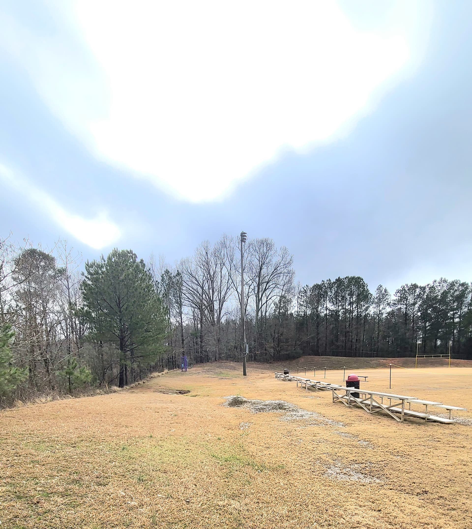
Here’s what I wrote in the supplemental:
“Great place to exercise. This can’t be seen on satellite. In the second photo, you can see a light pole, look for that on satellite.”
So, I didn’t write a ton of information, but I put enough that I thought people would understand how to locate it. Honestly, I should have written more but I submitted probably 30 things that day and “writing fatigue” is real when you do that. I was kinda trusting reviewers to understand that this was an empty park being filled up with wayspots.
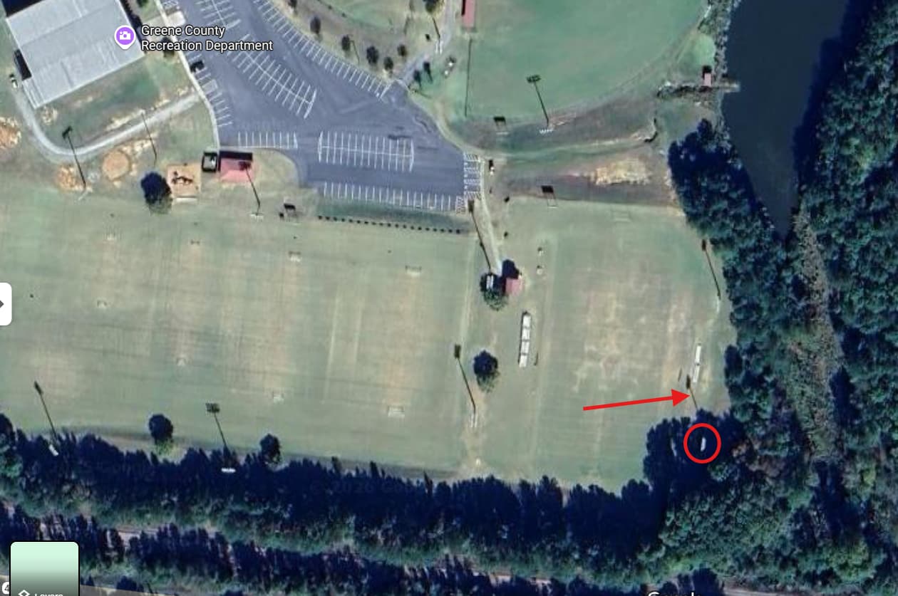
Here’s the satellite view. I’ve circled the light pole and pointed my arrow at the shadow the light pole is casting. When you compare the supplemental to this satellite view, you would see that where I submitted the exercise equipment was accurate (or as best I could make it).
excelente muchisimas gracias