Additional Information (if any): Site has been visited and I can confirm that the portal no longer exists, the photograph of the portal come from a Facebook post, and the picture is very old. There is mention of Scottish Natural Heritage, the organisation rebranded many years ago to ScotNature. Attached are photos of the location showing no portal:
I noticed that you’re using Ingress specific terminology in your post. Ingress is no longer connected to Wayfarer, so you won’t be able to get Portals removed on this forum. You’d need to go through the relevant channels with the Ingress/Niantic Spatial teams to get it removed.
Of course, I had completely forgotten about that split. Seems that NianticSpatial have no signposted appeals process. Hopefully no one falls off the cliff on a misty day walking to this POI!
The location of the wayspot/portal seems to be sufficiently inland to be safe to access. Portal removals can still be sent to Recon and do appear to get acted on, but removal for a faction war should still be getting frowned upon.
Google maps satellite imagery is deceiving for vertical drops because of the angle, but as you can clearly tell from the photographs, there is a sheer drop. Irrespective of that, the sign is not physically there, which you can also tell from the photographs. Bing satellite imagery is a little clearer of that location.
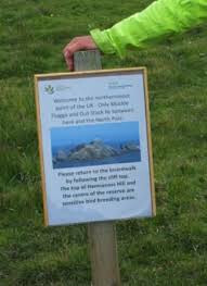
There was a sign some years ago, but not at that location, it was to the South and easily accessible on the main trail path, and indicated a trail to the top of Hermaness before the boardwalk was put in place, I’d say around 2021.
I’ve made a report to Ingress recon.
Edit: No faction war, I live here and walk that nature reserve often, the POI is purely dangerously positioned and non existent, a removal no matter which faction one aligns with.
I suspect you need to prove your photographs are of that location. There is simply no way for Niantic or Niantic Spatial (referred to as “Niantic” within the Ingress community, which really confuses things here) to know that your pictures are of that location, without proof.
(I referenced faction wars purely because that portal in Ingress is currently owned. Had it been unclaimed, I wouldn’t have).
I was at pains to make sure that I uploaded the original pictures complete with EXIF location data, that’s a shame if they are stripped by the forum software,
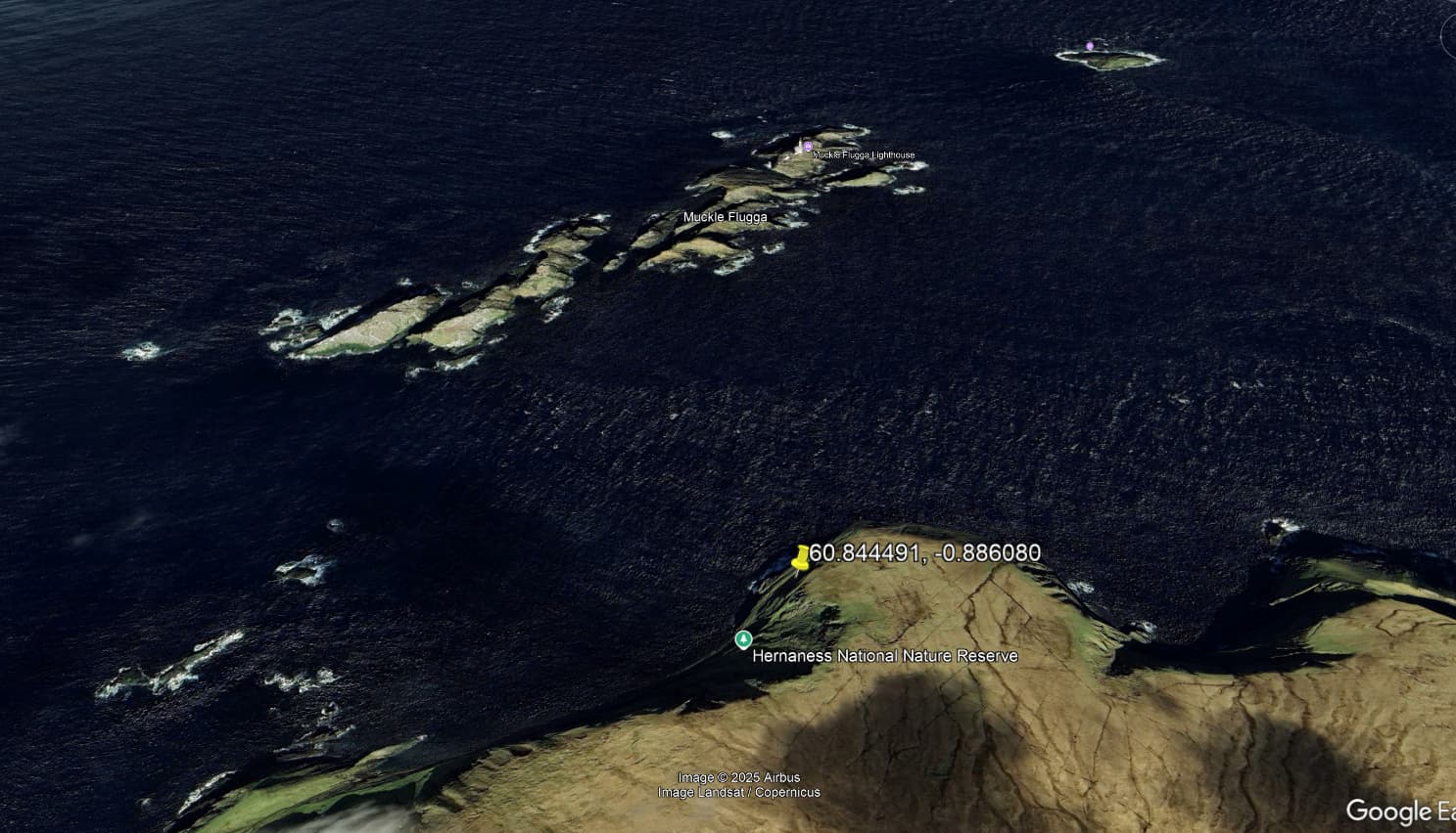
There is no such place as the “Northernmost Point of the United Kingdom” and if we are to be pedantic, then it would not actually be there but on Out Stack, which is officially the most northern point and about 1.8 miles North of Unst, the most Northernmost point of the UK mainland is Dunnet head, so it fails on that score too.
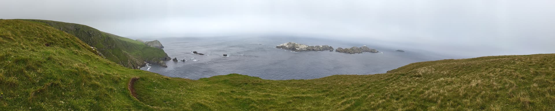
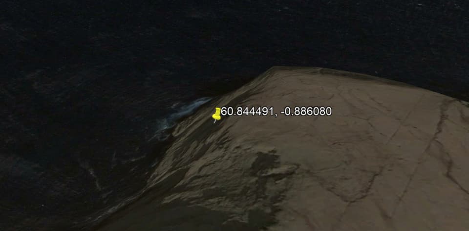
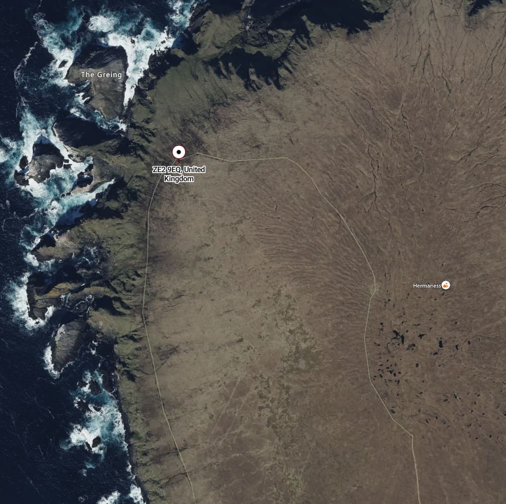
Yet again, ignoring the lack of sign or any other argument, the co-ordinates are off a cliff edge, I know, I was there yesterday thinking to myself that it’s a good job I know this area as that’s downright dangerous. The looking down at the wayspot/portal co-ordinates is at 60.844283, -0.885714 according to the image.
I have a problem with viewpoints on beautiful stretches of OK coastline being POI without an anchor. You could quite literally have hundreds of them close together and there’d be no reason for one to be selected over another.
This specific location came with a sign. If that sign has indeed gone and the wayspot is titled after that sign, then the wayspot being removed makes sense.
Google has a marker for “Northernmost Point of United Kingdom” at the actual northernmost point on Out Stack as @arfski referenced. The POI called “Northernmost Point of United Kingdom” is on Unst and is misnamed.
When the POI was created was it considered the most northern point rather than the stack or has it always been mispinned?
I guess the source of the original information coulldhave been wrong.
The sign specifically tells you to stick to the paths, it would not be a good idea to place a warning sign requesting this well away from the paths and off a cliff edge. If you reverse image search, you can see that none of the pictures are of a sign on a cliff side.
Without taking a trip to Shetland, it’s hard to say where the pin SHOULD be. Disappointingly few photospheres in that area, reverse image search didn’t come up with any definitive locations either..
I’m going to reply to my own post as I now know what has happened here. There is another POI called “Steep Path to The Hill” at 60.839877,-0.894713 with exactly the same picture in a place that I would expect it to have been. Something is even more fish about the portal over the edge of a cliff that uses the same picture.
Technically not the same photo, but definitely the two wayspots (Steep Path to the Hill @ 60.839877,-0.894713 and Northernmost Point of United Kingdom @ 60.844491,-0.88608) use photos of the exact same sign at the exact same point, despite being 700m apart as the crow files.
The sign for “Northernmost Point of the UK” is different between the two photos. The photos from the Mission Creator are similar to each other but not quite the name - still obviously of the same place.
Luckily Ingress itself (via intel) has the photos you just posted. It would be harder to say ‘cheating’ with the Lightship photos, but with the Ingres photos, that is undoubtedly what happened.