No-one has said the trail is unsafe. Everyone has said that that specific location is not safe for a wayspot.
“Why does one need to stand at a waypoint?”
Because that is what wayspots are. They are places you are expected to stop at. That most people walk past them is not relevant to that. Every wayspot can potentially become a gym or something else which requires extended stoppage.
I have a lovely old milepost near me that will never be a wayspot because it is against the roadside against a wall with no pavement. I can get there safely for a brief period, but I definitely cannot stop there.
I accept that this can never be a wayspot and move on to other POI.
A waypoint is a marker along a path it is not necessarily a place to stop and hang out, if this is your understanding many of the current waypoints in the game need removed. Doing this and having no ability to discern why a waypoint such as this should exist is exactly why Niantic games are declining instead of expanding. These community signs are elegant markers of communities along a major trail in the suburbs that connect communities and parks. If denied waypoints such as this Niantic games growth and reach end in Cities. As out in the rural areas and country pathways where exploration of nature is way safer than the Cities we do not have any other monumental markers that suffice your judgement.
Well that is too bad for that location, however you can stop on either side of this submission and camp out all day safely is you so wish and still interact with it.
As @Mystogan5097 said, it is not my judgement that matters.@Mystogan5097, myself and everyone else who posts here (except those marked Niantic) are just individual wayfarers. We don’t set the rules.
Wayspot are expected to be safe at 0m because sometime we need to scan them. Back then at ingress, we need to use ultrastrike at 0m too
I personally like neighbourhood sign. But for this particular nomination, it have safety concern. If you believe this is incorrect, you are free to resubmit. Noone is stopping you
That is the problem here, the “rules” are guidelines, this meets all of the guidelines laid out. Your interpretation of those guidlines is what is flawed.
I started playing Niantic Games in 2016 and played a lot until 2018. It got stale having to go to crowded City areas to play. I recently came back to the games and reached a level to where I could participate in adding to the games accessibility to those of us that live in rural areas. The comments here have shown me that Niantic games will never expand or become friendly to suburban players. If significant markers such as this along major miles long trailways are rejected, these areas will remain deadzones within the games. My time and the money I have spent playing Niantic Games is a total waste.
There is also this from Fort Wayne Parks and Recreation with links explaining the project.
The Bass Road Trail, part of the broader Pufferbelly Trail network in Allen County, Indiana, is being developed in several phases as part of a road-widening project between 2020 and 2026. As of the latest available information from 2025: - **Completed Sections**: - The section from Hillegas Road to North Thomas Road was completed in November 2021.( Completed Trail Projects - Fort Wayne Trails ) - The 8-foot-wide asphalt trail from the newly constructed Bass Road Trail heading north into the park, running parallel to Flaugh Ditch with park benches and scenic overlooks, was completed with a ribbon-cutting ceremony on July 10, 2023.( Completed Trail Projects - Fort Wayne Trails ) - **Ongoing and Planned Construction**: - The section from Hadley Road to Wescott Road is under construction with an anticipated completion date of mid-2024.( OTHER TRAIL PROJECTS IN OUR COMMUNITY - Fort Wayne Trails ) - The section from Wescott Ridge to Scott Road began construction in 2024, with an estimated completion date in 2025.( OTHER TRAIL PROJECTS IN OUR COMMUNITY - Fort Wayne Trails ) - The bridge over Durnell Ditch, part of the Bass Road Trail project, was under construction as of March 2023 with a completion date of May 31, 2024.( OTHER TRAIL PROJECTS IN OUR COMMUNITY - Fort Wayne Trails ) - **Overall Status**: The Bass Road Trail is a 10-foot-wide multi-purpose trail being constructed along the south side of Bass Road between Scott Road and Hadley Road. Right-of-way appraisals are complete, and the project was bid in March 2023. The entire project is expected to be completed by 2026.( OTHER TRAIL PROJECTS IN OUR COMMUNITY - Fort Wayne Trails ) For the most precise completion status as of August 2025, particularly for the Wescott Ridge to Scott Road section expected to finish in 2025, you may need to check with Fort Wayne Trails or the Allen County Highway Department for real-time updates, as some sections may have progressed or faced delays since the last reported data.( OTHER TRAIL PROJECTS IN OUR COMMUNITY - Fort Wayne Trails )
It’s not @salixsorbus ‘s interpretation though. There have been multiple similar examples of things on medians being deemed unsafe by Niantic themselves. If you want to complain about this, complain to the person who put the thing there in the first place instead of putting it on either side of the road where it would’ve been safer to access.
Of course, that still wouldn’t change the fact that this is still a generic neighbourhood entrance sign without any evidence to the contrary, and that it’s therefore not a great place to socialise, a great place to exercise, or a great place to explore.
If you search through here, you will find many of us of the opinion that they do not meet criteria. As well as some appeals decisions. Just because they have ever been accepted does not mean they ever met criteria.
I was beginning to suspect this was Indiana, without bothering to check where Fort Wayne was, just because of the nature of the sidewalk and the roads. It’s much like western Indianapolis.
I always feel a little sorry for anyone in the midwest who likes walking and doesn’t live downtown. In the UK, we have pavements. We take them for granted and just consider them infrastructure, but in the USA, somewhere you can walk is remarkable.
That sign is for a neighborhood. It is not for any kind of trail. Trust me, I used to work in construction where we built neighborhoods. The builder made that sign to advertise their homes. The city had nothing to do with it. It has nothing to do with any trail.
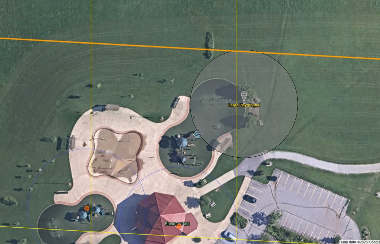
That location is close to Buckner Park. I think you can squeeze in 2 more wayspots, maybe 3 there.
I’ve pinned the large playground that can be added.
I think you should also get a wayspot for the open field in the middle but that is going to be a little bit more difficult since there is not a good anchor point. In fact, I would try to nominate the open field and the walking track at this park. But those will both be kinda hard - probably requiring an appeal.
I would look at what this building is over at the church in between the park and this neighborhood. If it’s some kind of gathering spot, it could be eligible. But it’s hard to tell from the map if it’s just a storage building.
The point is the community recognizes it as more than your dismissive contractor advertisement assertion. It is a marker to lead people along the trail to Buckner Park. One where community residence can create a route within the games to walk to the park and new venues being built down the street. By the way they are spots already and additions such as picnic bench areas and pedestrian bridge walks don’t appear to pass muster either. This community has an issue with discernment of the guidelines and neglect the overall Wayfarer Mission Statement.
I truly hope that this post will be the final straw that convinces staff that a clarification is needed for these. I don’t think they ever will after my last attempt at asking for one.
I believe that “unsafe access” was an easy way for reviewers to reject this nomination since we cannot reject for “does not meet criteria” in the current review flow. That also needs to be corrected, but since it has been like that since 2023, I don’t expect it will be, either.