POI disapeared (49.956819, 20.752194). Are you able to check why?
If you want help from the community, it would be useful to say what the POI was.
I don’t think it was on school grounds. The google maps pin at that precise location is on grass outside of a fence, with direct access from the pavement on two sides. I wouldn’t consider this to be school grounds. If it was inside the fence, that’s different..
There’s a noticeboard nearby, but nothing at the location given.
Yes it was, but noticeboard is also missing from the game view.
It was Memorial to the murdered villagers.
Hello and welcome
If it is in that area in front of the school it would be best if you could provide evidence that it is not considered to belong to the school.
Isn’t the photo I took at the nomination sufficient? The monument is the property of the association. Yes, it has been located next to the school, but it is not on the school’s enclosed grounds but on a square.
Even the exterior of a School Fence is classed as School Property?
As wayfinders we don’t have access to that information and we are using our experience to suggest possibilities.
If you could post as many details as possible we can probably get close.
The proximity of the school could be a strong candidate for a reason.
If there are sound reasons you can ask for it to be restored in Wayspot Appeals. You will need evidence that it still exists ( geotagged recent photos) and if there are outstanding questions about school property evidence that it’s not on school property. If you don’t provide the evidence it lessens your chance of success.
This one is showing in Lightship..

Tablica Informacyjna Obelisk Katyński
Jedna z tablic informacyjnych “szlak historii ludzi, miejsc i wydarzeń”. Opisuje życiorysy osób poległych w Katyniu.
It does look like an important POI but it’s possible that it is located on school grounds or possibly that someone thought the location was sensitive.
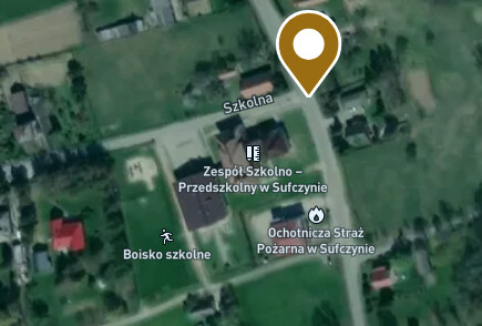
It’s really hard to tell what the boundary of the school is. Perhaps the local council has a definitive map?
This object is located on the property of a school which makes it ineligible.