So I have been an active contributor to the Wayfarer Community for more than 4 years and have submitted + reviewed over 5000 POIs.
Now a friend of mine that is also very much into pokemon go learned the basics from me and started adding some POIs in his nearby forest trail.
However when i explained to him that there are limits and rules (f.e. s17 cells determine if there can still be a POI added or s14 decides about gyms) he used the “wrong” cells (at least to my knowledge). He said after researching he found out that s16 are for pokestops and s18 for gyms (or the other way around). However i said to him that i believe this to be false.
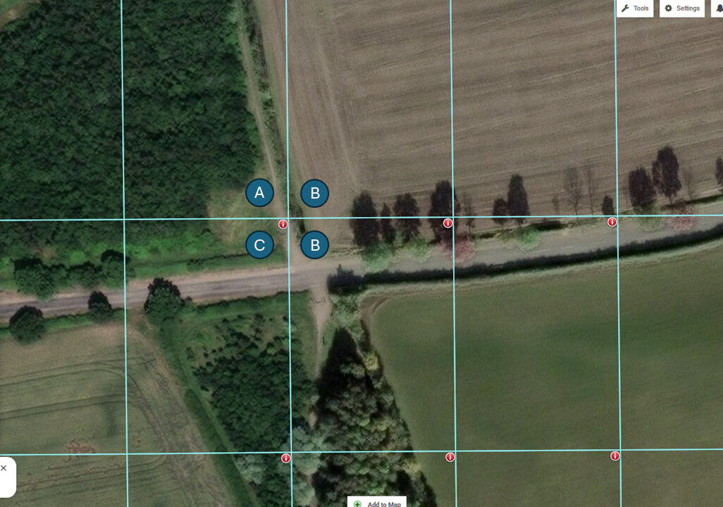
I added a screenshot - 3 more POIs got accepted, they are all in real locations - i helped him, but he submitted them himself. I also thought there is a fixed “area/range” around a POI in which no other POI can be created (even IF its a different empty s17 cell).
Did i do it wrong the whole time?
I am really curious. Maybe there are some rules that I am unaware off or my knowledge is wrong/not complete.
How can it be, that the POIs are so close to each other? Isnt there a minimal “area” around it that prevents new POIs from being created?
Or are there special rules in a forest/park area? Or is there no “area” around a POI that prevents another POI of being created in a neighbouring cell?
Several years back when the map was controlled by Ingress, there was a 20 meter spacing requirement in addition to the 1 per L17 cell. Since the map became a common map (and now no longer used by Ingress) that all games drew from the 20 meters in PGo disappeared. At the corner of 4- L17 cells you can in theory have 4 waypoints, inches apart.
A word of warning, you should never try to misplace wayspots in another cell because that can be considered a serious act of abuse. I’m not sure about how other Niantic games deal with wayspot proximity, but as GrandpaTP says Ingress (not longer part of Wayfarer) uses a simpler proximity method.
Thank you!
Yes! Those were real locations we added, but i told him he can only add 1 probably, but he just submitted all 3 and they were accepted, so i was confused thanks alot guys!
I have been assuming that you mean that they were all added to Pokemon Go when you say this. But whether it will show up in Pokemon Go or not has nothing to do with a nomination being accepted. And submitting something where it doesn’t actually exist in order to get it to show up in Pokemon Go is abuse, so be sure your friend doesn’t just pin in empty cells unless the real life object is actually there.
I have found Pogo Map to be accurate with the cells when using Street Map.
They have stated themselves that due to using different satellite mapping it can be slightly out.
The waypoints are user generated and can be placed by dropping a pin on the map so not always up to date or accurate. There is an accurate method using the Long / Lat Co-ords.
The fact that IITC is getting more and more inaccurate I believe that Pogo Map is an easier way to check cells (using street map) if you haven’t already installed IITC.
If you are willing to spend time adding / correcting waypoints it can be great for checking for occupied cells etc.
The new “wayfarer” map (soon ) has a chance to make Pogo Map obsolete for most people depending on what it includes.
Which is why I stated about using the Long / Lat method…
Bring up waypoint in game.
Use “View In Map”.
This will display the Long / Lat.
Use this in Pogo Map.
I have not seen any errors on the cell lines when done in this way.
Which is why I also mentioned “willing to spend time”.
As IITC is getting less accurate as time goes on IMO Pogo Map is the easiest to set up just to check Cells (not where waypoints are sat in there which we don’t have anything ideal yet).
It’s the cell lines that are mispositioned with respect to objective geographical coordinates. It doesn’t matter in the slightest which map does the visual in the background (it can also be no map at all) as long as these things are mismatched.
That happened often enough (including on this forum) that we can’t recommend it as a general purpose tool, as we then have to do additional tech support on “why didn’t it appear”.
I went through my local town including surrounding areas and never had one showing in an incorrect cell once the Long / Lat method was used.
These matched the cells in IITC and where there was 2 waypoints on either side of a cell wall this was shown in Pogo Map.
The problem arises when people use the “Drop Pin” method.
Again, I will repeat that we don’t currently have a suitable map, hopefully the new map will make the current argument mute but until then we have 2 that do not do the job perfectly.
Either a 6 month out of date map which needs extensions or a user generated one that requires time and accuracy. 6 of 1, half a dozen of the other.